Dosya:Satellite image of Bolivia in June 2002.jpg

Bu önizlemenin boyutu: 521 × 600 piksel. Diğer çözünürlükler: 208 × 240 piksel | 417 × 480 piksel | 667 × 768 piksel | 889 × 1.024 piksel | 1.778 × 2.048 piksel | 5.279 × 6.079 piksel.
Orijinal dosya (5.279 × 6.079 piksel, dosya boyutu: 4,02 MB, MIME türü: image/jpeg)
Özet
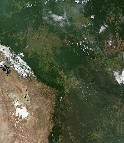
| Açıklama | Satellite image of Bolivia in June 2002. Normally obscured by clouds, Bolivia is amazingly clear in this true-color MODIS image acquired June 20, 2002. Bounded by Brazil to the north and east, Paraguay and Argentina to the south, and Peru and Chile to the west, Bolivia is completely landlocked. A good portion of Bolivia is dominated by the Andes, but it also lays claim to lush forests and pasture lands in the Amazon Basin.Bolivia's agricultural crops include soybeans, coffee, coca, cotton, corn, sugarcane, rice, potatoes, and timber. A number of agricultural plots are visible in central Bolivia. Some large plots are arranged in a circular star shape, with water sources at the center and the agricultural plots radiating outwards. Adjacent to them (down and to the right) are more traditional shaped plots (more rectangular).One of Bolivia's main exports is tropical timber. Visible in this image are areas where the timber has been harvested. The deforestation patterns tend to follow major roads first, then smaller roads adjoining main roads. These patterns resemble the growth of ice crystals and are best viewed in the higher resolutions of this image. Deforestation is visible along the green edge of the Andes in central Bolivia. |
| Tarih | |
| Kaynak | Slightly cropped from: http://visibleearth.nasa.gov/view_rec.php?id=3261 |
| Yazar | Jacques Descloitres, MODIS Land Rapid Response Team, NASA/GSFC |
Lisanslama
| Bu dosya NASA tarafından üretildiği için kamu malıdır. Aksi belirtilmediği sürece "NASA tarafından üretilen malzemenin telif hakkı olmadığı" NASA telif politikasında belirtilmiştir. (Bkz. Template:PD-USGov, NASA copyright policy page veya JPL Image Use Policy.) | ||
 |
Uyarılar:
|
Dosya geçmişi
Dosyanın herhangi bir zamandaki hâli için ilgili tarih/saat kısmına tıklayın.
| Tarih/Saat | Küçük resim | Boyutlar | Kullanıcı | Yorum | |
|---|---|---|---|---|---|
| güncel | 18.40, 18 Aralık 2004 | | 5.279 × 6.079 (4,02 MB) | wikimediacommons>Hautala | {{PD-USGov-NASA}} Satellite image of Bolivia in June 2002. Slightly cropped image taken originally from http://visibleearth.nasa.gov/cgi-bin/viewrecord?16839 . Normally obscured by clouds, Bolivia is amazingly clear in this true-color MODIS image acquired |
Dosya kullanımı
Aşağıdaki sayfa bu dosyayı kullanmaktadır: